Many believed in Australia for 1,000 years before its discovery. There had to be a commensurate weight — somewhere Down Under — to counter the northern land mass; an ‘unknown Southland’ which was crucial to maintaining the balance of the world. To confuse matters, this theoretical continent was dubbed for a while Austrialia del Espiritu Santo — in honour of the House of Austria.
A socially awkward Lincolnshireman, Matthew Flinders, in 1804, was the originator of Australia as the name for what had for centuries been called New Holland, but two French sailors, an aristocratic cartographer, Louis Freycinet, and a manipulative, one-eyed anthropologist, François Péron, showed for the first time the continent’s actual shape.
From the late 1700s, galvanised by the loss of their American colonies, the French dispatched seven expeditions in 30 years to seek a huge landmass known as Gonneville Land, named after a French sailor blown off course in 1503. None of these expeditions had marvellous outcomes for their commanders. Marion was eaten by Maoris, Kerguelen convicted of fraud, D’Entrecasteaux died of scurvy, while the most famous, La Pérouse, vanished without trace.
Napoleon — who had volunteered for La Pérouse’s expedition, but was rejected — kept alive French hopes of a replacement L’Amérique. In 1801, he authorised a scientific expedition captained by Nicolas Baudin, an aloof, dry-witted botanist, to ‘study the inhabitants, animals and natural products of the countries in which he will land’. A popular belief is that Baudin’s instructions included a ‘secret order’ to establish a French settlement in Van Diemen’s Land, discovered by the Dutch explorer Abel Tasman in 1642, and to claim the island (now Tasmania) before the English — and then to claim the western half of the nearby continent where England had raised her flag; so far, only over New South Wales.
Why else would large areas on charts mapped by Freycinet and Péron, two of Baudin’s officers, be marked ‘Terre Napoléon’? Had Baudin, in March 1802, not lost contact with his short-sighted hydrographer Charles-Pierre Boulanger off the Freycinet Peninsula (where I write this) and spent the next two months searching for him, then the French might have beaten Flinders to it and charted the mainland all the way to Spencer Gulf.
As it was, France’s achievement in becoming the first nation to map Australia’s coastline was ignored: when Péron’s Atlas at last appeared in 1811, three years before Flinders’s Voyage to Terra Australis, it aroused scant interest. By then, the baptismal melodramas which Diana Preston explores in Paradise in Chains had played themselves out.
The story about the founding of Australia has been well told before, not least by Thomas Keneally in Commonwealth of Thieves and by Robert Hughes in The Fatal Shore. What Preston brings to it in the absence of a French connection is an 18th-century willingness to follow in the wake of her leading English characters — a journey that takes her to Tahiti and Pitcairn Island, if not to Kupang in Timor, which has grounds to be considered the capital of her narrative as much as Sydney Cove.
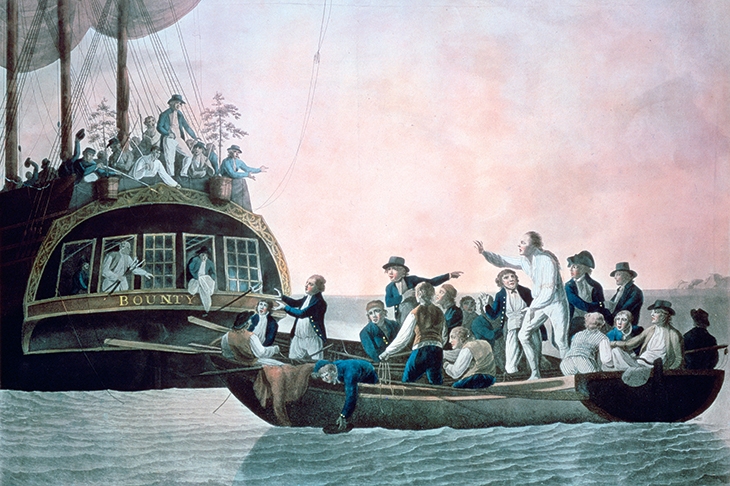
In the space of two years, Kupang’s local population watched sail into their harbour: on 14 June 1789, William Bligh and 17 survivors of the Bounty, after travelling 47 days and 3,600 miles in an open 23-foot boat; on 5 June 1791, William and Mary Bryant, their two children, plus seven other escaped convicts from Sydney Cove, after sailing 69 days and 3,254 miles in Governor Phillip’s stolen cutter; on 15 September 1791, Captain Edward Edwards with survivors of the shipwrecked Pandora, plus ten captured mutineers of the Bounty, after sailing 1,200 miles from the Great Barrier Reef. Excited to retell these open-boat journeys, which ‘certainly rank among the greatest such journeys ever made’, Preston has a challenge to keep her feet on several diverging rafts, and lash them together into a single, focused narrative.
She is right to restore Tahiti to its position as the fertile launch pad for Australia. She gives special prominence to the cantankerous Bligh and his suave mentor, the wealthy botanist Sir Joseph Banks, as characters who left their lasting thumbprints on these colonies, as did Cortes and Pizarro in Latin America. The Tahitian islands ‘discovered’ by the English in 1767, and visited two years later by James Cook, were described by Banks, who shared Cook’s cabin on the Endeavour, as ‘the truest picture of an arcadia… If we quarrelled with those Indians we should not agree with angels!’ A French botanist, Philibert Commerson, judged the Tahitians ‘free of any vice and prejudice’; further, their stunningly alluring women were ‘the sisters of the utterly naked Graces’, for whom ‘the action of creating a fellow human being is a religious one’. The Tahitians reciprocated with a corresponding passion for anything made of iron. The price of a virgin being ‘three nails and a knife’, many a pock-marked, toothless sailor was soon extracting nails from his ship’s hull to reward sexual favours. Nor did the natives simply covet metal objects. An embarrassed Banks had to return aboard scampily clad in Tahitian cloth after his clothes were stolen while he was in flagrante delicto at the bottom of a canoe with a Tahitian girl.
On his return home, the much-affected Banks immediately ‘ended his engagement to the wealthy heiress Harriet Blosset’. More significantly, he convinced the Admiralty to send back to Tahiti the five-foot, blue-eyed, only son of a Cornish customs official, William Bligh, ‘to bring the breadfruit plant’ with which, Banks argued, England could feed her starving slaves in the West Indies — following the loss of her own American colonies. Tahitian breadfuit was, in Preston’s words, ‘a kind of manna from heaven as freely available as the island’s beautiful women, only waiting to be plucked from the tree’.
In another significant decision, Banks was responsible for promoting Botany Bay in New South Wales as a destination for English convicts, now that American ports were denied them. The irony here: Banks’s twin project in Botany Bay would need Tahitian breadfruit a lot more than England’s Caribbean cane fields.
If Tahiti was a Utopia, then Sydney Cove was its opposite. ‘In the whole world there is not a worse country,’ lamented Major Robert Ross, commander of the marines sent to guard the first batch of 759 convicts, most of them petty thieves. Instead of a landscape with a climate like Toulouse, as Banks had promised, with plenty of fish and fresh water, and timorous natives, the First Fleet had landed in unforgiving, arid, stunted scrub with no pliant women, no food, and hostile locals who, accorded to Lieutenant Philip Gidley King, ‘desired us to be gone’.
Within two years the situation had grown so critical that Mary Bryant, a convicted highwaywoman, decided to escape with her family: ‘an open boat into the unknown was the lesser of two evils’. Arrested in Kupang and taken back to London, she and her four surviving companions declared they ‘would sooner suffer death than return to Botany Bay’.
That the fragile young colony did not revolt was due to its fair-minded first governor, Arthur Phillip. In Tahiti, by contrast, Bligh’s narcissistic and volatile character, more than the allure of young women, sparked Fletcher Christian’s ‘unpremeditated’ mutiny.
Preston enjoys reminding us that this was not the last mutiny provoked by Bligh. In 1806 — again at Banks’s behest — Bligh arrived in Sydney Cove as the colony’s new governor. The catalyst this time was an appalling ancestor of mine, a profiteering officer in the New South Wales (‘Rum’) Corps called Anthony Fenn Kemp, who steadfastly resisted Bligh’s attempts to clean up the corruption in which Bligh himself participated. ‘What do you think he told me?’ Kemp railed. ‘Yes! Told the oldest merchant in the colony — that he came here to protect the poor. That is not the Governor WE want!!!’ At 6.30 p.m. on 26 January 1808, the 20th anniversary of Australia’s foundation, Kemp marched up the drive at the head of the Rum Corps, sword drawn, into Government House. After a couple of hours, Bligh was discovered in a room upstairs. One of Kemp’s soldiers noticed a bedcover twitching, prodded it with his musket and struck a boot. There was Bligh, covered in spiderwebs and with his shirt hanging out.
If the connections that Preston makes between her different narratives seem at times as arbitrary as the dispensation of English justice during this supposed Age of Enlightment, then it does not detract from the skill with which she reweaves a familiar story. Having doggedly followed their trails on the page as well as on foot, she is well placed to judge the destruction wrought by her characters, best summarised by the Pandora’s surgeon George Hamilton after drawing anchor in Tahiti. ‘Happy would it have been if these people had never been visited by Europeans.’


Comments